
Groundwater national portal
Glossary A B C D E F G H I J K L M N O P Q R S T U V W X Y Z
Basin Committee
The Basin Committee brings together the different public and private water stakeholders. Its purpose is to debate and define in a concerted fashion the main policy areas for water resource management and for protecting natural aquatic environments, at large river basin district level. This body stands out due to its area of geographical competence being based on a river basin, and due to its specific consultation, orientation and decision-making missions, and its broad and diverse make-up.
Today there are seven basin committees in mainland France, corresponding to the seven major French river basin districts, and four basin committees in the DOM.(Overseas Départements) of Guadeloupe, Martinique, Guyana and Reunion Island.
BSS
(see BSS Code)
BSS Code
The BSS Code (or national SANDRE Code - French Data Reference Centre for Water Code) corresponds to the national file code for any underground installation that has been declared and has therefore been entered into the BRGM (France’s Geosciences Technical and Scientific Centre) BSS (Underground Strata and Hydrometric Information Databank). The code enables “any geology-related object” to be designated, particularly any underground water points, whether they are wells, springs or boreholes.
Since 1997, SANDRE has used the BSS code as the national ID for underground water points. This unique and unchanging code enables each water point to be carefully identified, thus facilitating the exchange of information between partners (contracting authorities, Department of Social Services, the Water Agency, Regional Departments for the Environment).
The technical data associated with this code (geographic coordinates, depth and geological profile) enable the abstraction points to be precisely located and to identify the aquifers being used.
How is a BSS code made up?
The BSS code is obtained by linking a BSS index (ten compulsory letters) and a BSS designation (from one to six letters), separated by the letter “l”:
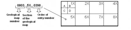
- The BSS index is established based on the position of the point on the geological maps of France (as set out by the IGN (National Geographical Institute), with BRGM numbering) and is structured in the following way:
- The first four figures of the index designate the BRGM number of the geological map on which the water point is located to a scale of 1/50,000.
- The next two letters - a figure, followed by an “x” - indicate within each of the eight compartments of the map the water point is located (this map may be subdivided into thirty-two sections if the points are very dense, in this case the letter X is replaced by A, B, C or D).
- The last four figures correspond to the BSS file number, with files being numbered in accordance with their order of entry.
Example: 08035X0398
- bss code
- Geological Map 1/ 50,000 Number 0803 subdivided into eight sections
- The BSS designation, providing additional information about the water point, is separated from the BSS index by an “l”, and is made up of letter(s) or number(s).
Example: 08035X0398/F
In order to enable data to be shared, this code must be written in accordance with the above rule, with no spaces or dashes, and with the zeros at the start of the index and the designation being included.
Examples:
Correct method: 08035X0398/F
Incorrect method: 8035X398/F
803-5X-398/F
0803 5X 0398/F
803 5X 398/F
803 5 398/F
Etc.
How are BSS Codes allocated?
For any underground abstraction exceeding a depth of 10m, the contracting authority (or the contractor) is obliged to make a declaration, before work begins, to the Chief Mining Engineer (Director of the DRIRE (Regional Department for Industry, Research and the Environment) or the head of the departmental sub-division) in accordance with Article 131 of the French Mining Code. This declaration states the details of the contracting authority, the location and type of work, and the specific features of the water abstraction. The declaration form is available from the State departments responsible for supervising water (DDAF (Departmental Agriculture and Forestry Department), DDASS (Department for Social Services), DRIRE (Regional Department for Industry, Research and the Environment), DDE (Departmental Infrastructure Department) and DIREN (Regional Departments for the Environment) or from the regional geological departments of BRGM.
Based on the information passed on by the Regional Departments for Industry, Research and the Environment and any additional questioning of the contracting authority, the BRGM allocates a BSS code to the completed installation.
For water points of a depth under 10m, and which are therefore not subject to declaration, the research department, drillers, owners or contractors can send a file directly to the BRGM so that BSS codes can be allocated. This file must contain as a minimum:
- &nb?p; The name of the installation’s owner and the person making the declaration (contractor).
- The precise location of the water point: the département, local area, locality, X and Y coordinates, the corresponding Lambert Zone, and a precise site plan.
- The type of installation: borehole, well, spring etc.
BRGM is responsible for allocating BSS codes. The code is allocated in practice by the BSS contact person from the relevant Regional Geological Department. The contact details of the BRGM regional departments can be found on:(-> http://www.brgm.fr]. All the allocated BSS Codes are stored and managed in the BRGM Underground Strata and Hydrometric Information Databank, which can be viewed on the http://infoterre.brgm.fr/. Finally, the BSS contact person in the relevant Regional Geological Department can be contacted if any further information is required.
![]()
![]()
