Glossary A B C D E F G H I J K L M N O P Q R S T U V W X Y Z
Time Series of Piezometric Levels
Piezometric levels over time are defined either as an NGF level, or in relative depth.
NGF level
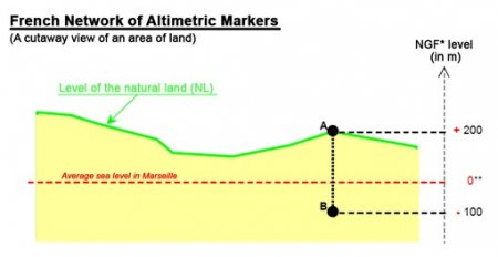
The level of the piezometer over time is defined as an NGF level in accordance with the altimetric system used for the piezometer when measuring is carried out.
The NGF (a network of altimetric markers throughout the country), set up under the supervision of the IGN (National Geographical Institute) is the framework of reference. This network of markers enables altitudes to be expressed using the same and unique reference system, namely in relation to the same and unique basic point (or level zero). Level zero corresponds to the average sea level in Marseille. This point can be used to work out the altitude of any other point.

Relative depth
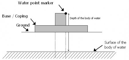
The time series of piezometer levels can be expressed in relative depth in relation to the water point marker. Each water point has two main marker points: the water point marker and the altimetric references. For explanatory purposes, the points are set out below in the example of a standard water point.

The water point marker is the measuring marker used to establish the level of the body of water and is located straight above the water point (edge of the bore piping, well coping, pontoon on a gravel pit etc.)
It usually acts a marker for a given period of time and can be positioned using a relative height vis-à-vis one of the altimetric references established on the water point.
The altimetric references enable the measurements obtained at several water points to be combined to find out about the state of the water body over its entire surface. Three locations can be used as altimetric reference points: the top sill of the base (cladding), the ground at the foot of the water point (ground) or the marker point can be used directly (edge of the pipe).
The altitude of an altimetric reference can be determined using various methods: maps, surveyor’s report, GPS etc and is only valid for a given period. Specifying the altitude of this reference point enables time series of piezometric levels to be continued when the water point has been damaged (pipe section) or changed (construction of new cladding).
Type of Aquifer Zone
(See Aquifer)
Type of Water Body
(See Groundwater Body)


