Glossary A B C D E F G H I J K L M N O P Q R S T U V W X Y Z
Geographic Coordinates
The geographic coordinates (or “geographic points of reference”) of a place are its latitude, longitude and altitude in relation to sea level. In order to get one’s bearings on the surface of the earth, another system, known as “cartographical markers” is used.
To get a location on the earth, it is necessary to use a geodesic system from which the geographic coordinates found on maps stem. These coordinates can be expressed in longitude and latitude (so-called geographic coordinates), or as a flat cartographical representation (so-called projection coordinates).
The standard projection in France is a Lambert-type conical shape (NTF geodesic system). With the aim of minimising deformations (linear alterations), France was divided into four zones. A projection known as “extended Lambert 2” covers the whole country for requirements of a national scope. The inconvenience of this extended system is that the linear alteration increases towards the North and South.
The Cartesian coordinates X and Y of a water point are the coordinates used in the projection, which is normally Lambert 2, and is extended to all the water points located in mainland France and in Corsica. The projection is expressed to a maximum scale of one metre. For water points located outside of mainland France, coordinates are expressed in the local projection system.
Good Chemical Status
Chemical status is an assessment of water quality based on concentrations of pollutants, particularly priority substances. Chemical status has two grades: good and poor.
A body of surface water achieves good chemical status when pollutant concentrations do not exceed environmental quality standards.
The environmental quality standard is based on the concentration of a given pollutant in the natural environment which, in order to protect human health and the environment, must not be exceeded.
A body of groundwater achieves good chemical status when pollutant concentrations do not exceed quality standards and do not prevent associated bodies of surface water from achieving their objectives.
Good Quantitative Status
Quantitative status is an assessment of the balance between abstraction and requirements linked to surface water supply, and the natural recharging of a body of groundwater.
Quantitative status has two grades: good and poor
The quantitative status of a body of groundwater is considered to be good when abstractions do not exceed the available resource’s capacity for renewal, taking into account the need to supply surface aquatic ecosystems, sites and wetlands that are directly dependent on the body.
Good Status
Good surface water status is obtained when a body of surface water achieves, as a minimum level, “good” ecological and chemical status.
Good groundwater status is obtained when a body of groundwater achieves, as a minimum level, “good” quantitative and chemical status.
Good status needs to be achieved by all water bodies by 2015, in accordance with the Water Framework Directive, unless the deadline is extended or less stringent objectives are defined.

Groundwaters
(see Aquifer)
All water found under the surface of the ground in direct contact with the ground or substratum and which travels at varying speeds (days, months, years, centuries, millennia) through cracks and pores in the ground and in rocks in saturated or non-saturated environments.
Groundwater
The water contained in a permeable fraction of the earth’s totally saturated crust, as a result of the infiltration of the water into the smallest cracks of the substratum and its accumulation above an impermeable layer. These bodies only form true underground rivers in karstic areas.
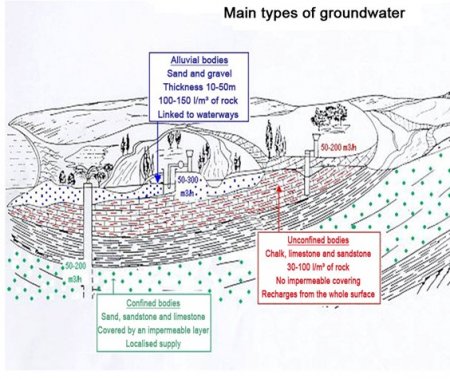
Groundwater corresponding to water that has infiltrated into the ground, moving around in the permeable rocks of the substratum, forms “reserves”. Different sorts of bodies can be distinguished using various criteria. These criteria may be:
- Geological:
- Alluvial bodies (a porous strata close to the surface).
- Bodies in fractured geological strata (limestone or volcanic)
- Bodies in karstic strata (limestone)
- Bodies in porous environments (sandstone, sand).
- Hydrodynamic:
- Alluvial bodies, volumes of groundwater contained in alluvial areas, generally unconfined and connected to a waterway.
- Unconfined bodies, volumes of groundwater with an unconfined surface, i.e. subject to atmospheric pressure. An unconfined body is included in an aquifer which incorporates an unsaturated zone above the saturated zone.
- Confined bodies, a volume of groundwater isolated from the surface of the ground by an impermeable geological formation, subject to higher pressure than atmospheric pressure. Their piezometric surface is greater than the roof of the aquifer that contains them. Water, which is pressurised and moves very slowly around the body, is protected from potential surface pollution if there is no communication with the surface or other bodies (either naturally due to faults or caused by boreholes).
- Regulatory (France’s Water Law): interlinked bodies, linked to a waterway.
The same body may have an unconfined and a confined section.

Groundwater Body
A homogeneous section of an aquifer, lake or coastal zone. Groundwater bodies are a basic way of dividing up aquatic environments and are intended to be the WFD evaluation unit. A body of surface water is a distinct and significant section of surface water, such as a lake, reservoir, river or a canal, or a length of a river or a canal, transitional waters or a section of coastal waters. For waterways, bodies of water are mainly delimited using the size of the waterway and the concept of a hydro-ecoregion.
A groundwater body is a distinct volume of groundwater inside one or more aquifers. Bodies of water are grouped into homogeneous types, providing a basis for defining the concept of “good status”. Bodies of water are delimited using geological and hydrogeological criteria, with a body of water generally corresponding to part or all of the hydrogeological entities defined by the BD RHF reference system (see hydrogeological entity).
The boundaries of bodies of water are stable and long lasting (impermeable geological boundaries, stable piezometric watersheds.) A topology, based on the geological characteristics and the hydrodynamic behaviour of aquifer systems, is used to delimit them.
Any abstraction points providing over 10 m3/ day of drinking water or used to supply drinking water to over fifty people must be included in a body of water, with this principle meaning that practically all formations are incorporated. Deep groundwater, with no connections to surface waterways and ecosystems, from which no abstraction occurs and which is not likely to be used for drinking water due to its quality or due to technical-economic reasons, cannot constitute bodies of water.
Depending on its size, a body of water may to some extent be spatially heterogeneous, both in terms of its hydrogeological features and its qualitative and quantitative status.
Several bodies of water may be stacked on top of each other.
The topology of bodies of groundwater is based on the intrinsic (particularly the extent and type of hydraulic conductivity) and functional (type and speed of runoff etc.) characteristics of hydrogeological systems, and comprises two levels of characteristics:
A first level with two main characteristics enabling the water body to be allocated to one of the topology’s six classes and to delimit it:
- Types of water body, six types of water body have been identified: alluvial, bedrock, volcanic structure, non-alluvial predominantly sedimentary, composite hydraulic extremely folded mountain system, and a locally impermeable aquifer system: impermeable formations incorporating smaller unconnected aquifer units
- The type of runoff (unconfined / confined).
These characteristics are useful when calculating a water body’s intrinsic vulnerability to pollution.
There is also a second level of secondary characteristics which can be applied to a water body or part of a water body, and supplement each other. These characteristics may be shared by different types of water bodies. They should not lead to the water body being re-delimited. The selected secondary characteristics are:
- Karstification
- The presence of a coastal fringe (linked to the risk of saline intrusion).
- The characteristic of “grouped unconnected aquifers” which enables unconnected (either horizontally or vertically) entities, which belong to the same type of water bodies and are subject to the same sorts of pressures, to be grouped together.
A methodological guide describes in detail the method for delimiting groundwater bodies for each type that has been defined. The guide also provides examples.
Groundwater Body - River Relationship
Transfer of water between a groundwater body and a waterway. In accordance with the water level and the seasons, the body may either feed the waterway or is fed by it, particularly during floods. In karstic areas, this relationship is significant and localised.
We also speak of an interlinked body: a groundwater body close to a waterway, with hydraulic properties which are very closely linked to those of the waterway. The use of such a body causes a drop in the waterway’s flow, either because the body is providing the waterway with less water, or because the waterway starts to recharge the body.
Groundwater Directive
The daughter directive 2006/118/EC of 12th December 2006 concerns the protection of groundwater from both a quantitative and a qualitative standpoint. It aims to establish criteria for evaluating good groundwater chemical status. Good status is established using Community quality standards (for nitrates, pesticides and biocides) and by identifying pollutants and their threshold values which are typically found in so-called “at-risk” bodies of groundwater.

Groundwater Recharge (in the hydrogeological sense)
The volume recharging a groundwater body over a given period. Rainfall is the main source of groundwater recharge (see effective infiltration).
An unconfined body of groundwater recharges quite quickly during each precipitation event. The rise in water levels and precipitation events can be observed on a piezometric graph. Groundwater bodies recharge once the soil has become saturated, with the rainwater directly infiltrating at outcrop area level.
Recharging a confined aquifer is, however, a much slower process. Precipitation events are either not visible or barely visible on the piezometric graph. The rise in water levels depends on the distance of the outcrop (water takes longer to move through the soil and rocks), and local transfers between bodies of groundwater, amongst other factors.
Groundwater Supply Zone
A zone encompassing a set of supply installations which abstract groundwater from the same body.


