
Groundwater national portal
Glossary A B C D E F G H I J K L M N O P Q R S T U V W X Y Z
Hydro-ecoregion
A homogeneous area from a geological, relief and climatic standpoint. This is one of the main criteria used in the topology and delimitation of bodies of surface water. Mainland France can be broken down into twenty-one main hydro-ecoregions.
Hydrogeological Entity
A hydrogeological entity is a generic name given to a group of aquifer systems and hydrogeological areas. Between 1976 and 1980, as part of the Evaluation of France’s Hydraulic Resources carried out by the BRGM (Jean Margat et al.), the first maps dividing up mainland France’s hydrogeology were published. These maps were supposed to be the basis of a systematic hydrogeological classification, combined with a coded nomenclature, leading to the definition of five main categories of hydrogeological entity:
- Areas made up of large aquifer systems, with mainly unconfined bodies of water (Code 001-199)
- Areas made up of large confined aquifer systems (Code 201-299)
- Alluvial zones located in areas without a major individualised aquifer system (Code 301-499)
- Areas without a major individualised aquifer system, on sedimentary ground (Code 501-599)
- Areas without a major individualised aquifer system, on crystalline ground (Code 601-699)
From 1980, this initial national division was reworked and honed at river district basin level by various operators (BRGM, the Water Agencies) and then published. During this work, some contour boundaries were modified, some initially identified entities were subdivided and others were created from scratch, with a code being allocated to each of the new entities.
The first national synthesis of this work was produced in the form of map with a scale of 1/1,000,000 (BRGM, A.Landreau et al., 1993). This map was less detailed than the river district basin maps, with the authors having to simplify the contours and delete the smallest objects by grouping them together.
However, the codes allocated to the new entities created during this period still did not fulfil all the codification rules set out at the beginning, and the same criteria were not systematically used to subdivide the entities. This lack of homogeneity complicated the compilation of the synthesis and reduced its usefulness.
Faced with this, and in the light of the spread of Geographical IS, in 1995 the Ministry of Land Planning and the Environment, with the support of the BRGM and in partnership with the Water Agencies, began to discuss the issue and to carry out research with the aim of creating a true national groundwater cartographic reference system at a scale of 1/50,000, similar to the French Hydrographical Frame of Reference for Surface Waters (BD Carthage®). The aim was to divide the whole of France into hydrogeological units, produced in accordance with common rules, thus enabling information to be managed and shared, data to be built up and entered into databanks, and to evaluate and manage groundwater resources. From the start two levels were envisaged to respond to two different requirements: the national level, more orientated towards providing information about France’s natural heritage, and the local level, more focused on water resource management.
Confined groundwater is a hydrogeological entity that is trapped between two impermeable areas of ground. This means that the body of water is pressurised in the aquifer. A confined body of groundwater is also called a deep body of groundwater (for example the Eocene groundwater body) due to its depth. This is why these bodies of groundwater are less vulnerable to pollutant infiltration, as they are well protected by the impermeable “walls” of the aquifer and by its depth. In general, a confined body of water can nevertheless include an unconfined section situated on the edge of the aquifer where rainfall infiltrates and recharges it.
In addition, confined bodies of groundwater can “pile up” This layering of confined bodies of groundwater depends on the age of the formation of the geological stratum which contains them: the deepest are the oldest.
Please be aware: cartographical representations are not able to depict the piling up of confined bodies of groundwater, so it is important to keep this concept in mind when reading maps.
- hydrogeological entity
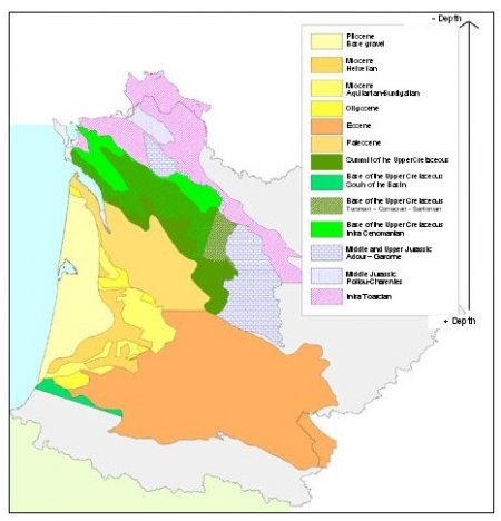
- Map of the hydrogeological entities (in the Adour-Garonne Basin)
Hydrometric Station
Station where readings are taken for one or several of the following elements for river, lake and reservoir waters: head, discharge, transport and depositing of materials, temperature and other physical water properties, ice cover characteristics and chemical properties of water. The HYDRO Bank recognises three statuses for the stations:
- Hydrologically significant
- Hydrologically insignificant
- Trial station
A station is hydrologically significant when it measures the outflow from a waterway which comes from an upstream river basin or a spring.
A station is hydrologically insignificant when it measures outflow from an industrial canal, an irrigation channel, the branch of a waterway, or a diversion canal.
A station is a trial station when it is created by a producer for its own usage, for training or simulation purposes.
![]()
![]()
