Glossary A B C D E F G H I J K L M N O P Q R S T U V W X Y Z
Aarhus Convention
Signed in Aarhus in Denmark on 25th June 1998 under the aegis of the United Nations Economic Commission for Europe (UNECE), this convention focuses on access to information, public participation in decision-making and access to justice in environmental matters. Applied by decree on 12th September 2002:Décret n°2002-1187 du 12/09/02 portant publication de la convention sur l’accès à l’information, la participation du public au processus décisionnel et l’accès à la justice en matière d’environnement (ensemble deux annexes), faite à Aarhus le 25 juin 1998.
Administrative Basin Commission
These commissions are set up in each river basin or group of basins, and are chaired by the Prefect Basin Coordinator. The commissions are made up of regional prefects, departmental prefects, heads of regional State environmental centres, the regional environment director, who has the role of basin delegate, and the paymaster of the region where the Basin Committee has its head office, as well as the head of the water agency.
The Administrative Basin Commission helps the Prefect Basin Coordinator to carry out his or her remit. The Commission is consulted about SDAGE (Blueprints for Water Development and Management), the programme of measures, and Blueprints for Forecasting High Water Levels
Alluvial Groundwater Body
Volume of groundwater contained in alluvial areas, generally unconfined and often connected to a waterway.
Altitude
Altitude is the height of a place or object in relation to a given level.
Altitude is also a parameter that expresses the gap between a given point and an average level. On land, this level is usually sea level (or “level zero”). Summits are linked with an altitude, with this being calculated using various indirect methods (geodesy, triangulation). There is a system of reference for altitude.
Aquifer
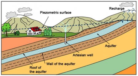
A continuous or discontinuous geological formation, either temporarily or permanently containing useable water, made up of permeable rocks (porous or cracked formation) and able to naturally or using a system (draining, pumping etc) release the water.
60% of the drinking water distributed in France comes from groundwater.

Aquifer Type (See Aquifer)
Available Groundwater Resource (Water Framework Directive Definition)
The long-term annual average rate of overall recharge of the body of groundwater less the long-term annual rate of flow required to achieve the ecological quality objectives for associated surface waters specified under Article 4, to avoid any significant diminution in the ecological status of such waters and to avoid any significant damage to associated terrestrial ecosystems.


